 Current
day Mt. Royal. Click on graphic to see larger version. Photograph by J. Brown Current
day Mt. Royal. Click on graphic to see larger version. Photograph by J. Brown |
Mount
Royal has been known
as Sandtown, Village at
Berkley (it is written as Berkeley
in some sources), Mantua Creek,
and in several very early deeds
is even referred to as the
"Village at the Crossroads."
SEE entire
"History of Mount Royal" in PDF format, scanned
from the original 1981 Town Centennial booklet. (2210
KB)
|
Early records indicate that this town had been settled since 1650 or perhaps
earlier. The village was named "Sandtown" or "Sand Town" because
of the abundance of sandy soil found in this area. Sandtown is mentioned by both
British and Americans as a place where skirmishes took place during the Revolutionary
War.
Henry
Rees, in his book, "Revolutionary Services" states:
November
1777, General Cornwallis at Billingsport sent his First Light Infantry over Berkley
Road to Sandtown to repair the bridge over Mantua Creek, which the Americans had
destroyed. On November 21st, 1777, the main army crossed the repaired bridge and
proceeded north, but the Seventh and Sixty-third Regiments were left behind to
occupy the town; guard the bridge, keep up communications with Billingsport; and
to collect cattle.
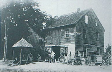 The town pump and
Hannold's wheelwright shop in Mount Royal
in the early 1900's. Mr. Hannold,
the wheelwright stands in the door.
[Note: this is probably Charles Holmes
Hannold]
Photograph graciously donated by Pete Miskofsky
In those early days,
boats were the main means of transportation, and because of its location near
Mantua Creek, this area was considered a thriving settlement. Transportation was
by boat, on horseback, or on foot. The charter of the old Gloucester-Philadelphia
Ferry provided for horses and foot-passengers-no mention of carriages. Carriages
did not come into general use until after the Revolutionary War. At that point,
the now named Berkley was a stagecoach stop where weary travelers found food and
lodging at the Berkley Hotel (see below). There was a toll gate along Kings Highway,
just north of the intersection.

Photograph
by J. Brown | On
November 1777 General Cornwallis sent his First Light Infantry over Berkley Road
to Sandtown [now Mount Royal] to repair the Mantua River bridge, which the Americans
had previously destroyed in order to stop their progress. |
In
1821, the name of the town was changed from Sandtown to Berkley, after Lord
John Berkeley of England, and once owner of this land (one of the proprietors
of West Jersey). Berkeley was at one time a stagecoach stop for weary travelers
where they could find food and lodging at the Berkley Hotel. There was a toll
gate along Kings Highway just north of the intersection, according to many residents.
 Photograph
of Gill's Store
[some call it "McGill's"]
in Mt. Royal, N.J.
from circa 1923 postcard
courtey of Jim Milsted
of Paulsboro. Click on photo
to see larger view. |
A
newspaper article in the Village Herald, dated 1825,
said "George W. Gill, proprietor of a store in
Clarksborough, has opened a store at Sandtown." [This
store in "Sandtown" was located in Mt. Royal, where
the current C&P Auto is now, on the corner of Kings Highway,
Berkley Road, and North Street]. |
| See
photo at left. SEE 2nd
version and 3rd version
of this store. My thanks to Pete Miskofsky for these 2 additional
photographs. |
Mount
Royal's original one room schoolhouse stood on the same site as the larger
school built after 1836.
In
Cushing and Sheppard's "History of Salem, Gloucester and Cumberland Counties"
it mentions an article about the village at Berkley in 1884. It states: "There
is at this place, an old Baptist meeting House, a
school house, a store owned by David Owen, Jr., the hotel of William
Keen, the harness shop of Charles Test, the blacksmith shop operated
by Robert Eldridge, the wheelwright shop of Charles G. Higgins,
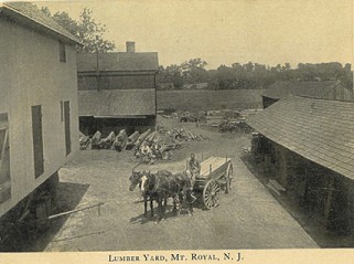
and a coal and lumber yard operated by George Parker."
"In
1850, Silas Richards had a shoe repair shop at the corner;
Amos Peaslee had a tannery shop on Kings Highway, and the town pump
was located in front of Mrs. Livezy's house near the wheelwright shop, also on
King's Highway."
SEE 1860 MAP OF BERKLEY
(Mt. ROYAL) - coming soon
Another
clipping dated 1869, says: "Joseph Livezy sold a small house and lot
to David B. Cloverdale for $225.00. Amos Peaslee
sold his double house adjoining the Baptist Church to Emmeline Platt for
$1150.00. James Munyan sold a 1/2 acre lot on Mantua Creek to George
Steelman for $100.00, and George Sigan purchased a 1/2 acre lot from
John Sigan for $80.00 and has nearly completed a neat and comfortable property.
John Siven sold a farm of 44 acres owned by the late Elizabeth
Lippincott to William Locke for $85.00 per acre, and Joseph Locke
purchased nine acres from Jacob Hughes for $1,000.00. There are still many
fine building lots to be had in this quiet pleasant village, and anyone looking
for a homesite would do well to visit and see the many advantages to be offered.
Lots atop the bluffs near Mantua Creek, are much sought after because of its fine
location."
An
article in the Gloucester County Times titled, "Notes of Yesterday"
said "Berkeley was a thriving community and a place of some importance in
earlier days. Small lots atop the bluffs near Mantua Creek commanded high prices,
and it was an important shipping point. Farmers started sending their crops to
Philadelphia, and it wasn't long before those living along the creek built small
sailing vessels and started hauling these loaded sloops to Philadelphia on a regular
basis."
In
early 1880, James Gould, Sr. sailing from Philadelphia to Berkeley with
a load of lumber and coal, was the business opportunity and started hauling produce
from both Hoffman's and Green's wharfs to the Dock Street wharf, Philadelphia.
About
1890, the boat captains of Mantua Creek secured the additional services of a tugboat
owned by Capt. Benjamin Bramell to help tow their schooners to Philadelphia
as well as to the Campbell Soup Co. wharf in Camden. These schooners were later
replaced by barges, or 'Lighters' and this means of transportation continued until
after the Second World War. In 1980 many men still living in the township recalled
driving their wagons to the boat landing and helping to load these baskets of
tomatoes onto these barges.
In
1890 when the post office was established, the name had to be changed in order
to avoid confusion with another town named Berkeley in the northern part of the
state. [Tercentenary; Centennial
| One
old oral tradition states that the village of Mount Royal was named after a can
of baking powder. This has never been confirmed, since there appears to be no
written reason for chosing this name. | 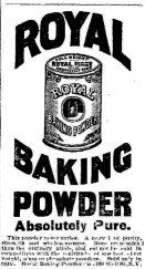 |
Heart
in Hand Tavern | Lacy House | Sickler Hotel | Blue Anchor Hotel | Berkley Hotel
| Mt. Royal Inn
Location: North West corner of intersection of Rt. 551
[Kings Highway] and Mantua-Paulsboro Road, in Mount Royal, NJ
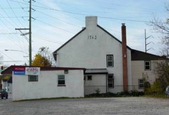 Mount Royal Inn
in 2003 - photograph by J. Brown
This
brick tavern, located at the crossroads in Mount Royal village, was kept in earliest
years by Theophulus Hillman. In 1813 it is known that William Sailer
was granted a license for the tavern at the Cross-Roads or Sand Town. Sailer was
also the proprietor of Death of the Fox Inn
in Clarksboro N.J.
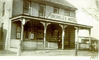
The
Berkley Hotel in 1923 - used with permission
thanks to Dolores Claeys of Sewell
for this photo |
Later
is was called the Heart 'n Hand Tavern. In 1869 it was called the Lacy
House -- it was here that Brigadier General William T. Cozens issued a general
order, as it was serving as the Army Headquarters of New Jersey.
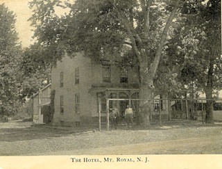 The
Hotel in Mt. Royal NJ circa 1910 The
Hotel in Mt. Royal NJ circa 1910 |
In
1899 it was known as the Sickler Hotel/House and then later was called
the Blue Anchor Hotel, and then the Berkley House/Hotel. It is currently
called the Mt. Royal Inn. Additions over time have changed its original
appearance.
The
Rising Sun Tavern
According to Lorena Headley, in "East Greenwich
Centennial--1881 to 1981," there were two taverns in the early village
of Sandtown (now Mount Royal). She quotes from Charles S. Boyer's book, "Old
Taverns and Inns of West Jersey," of an older tavern located near Mantua
Creek and Kings Highway, named "Rising Sun Tavern." Just when this tavern
was first established is not known, but John Ramb, also referred to as
John Rambo, was the proprietor in 1784. Micajah Clement kept it
in 1806. John Paul was the owner in 1809, and Joseph Heppard was
the proprietor from 1811 to 1817. Little information could be found about this
early tavern, but the John Ramb (Rambo) property, was once part of a large
tract located along the banks of Mantua Creek. In 1689 John Parker, yeoman,
purchased this tract from Andrew Robeson, a Swedish settler. Robeson had
been the Surveyor General of New Stockholm (Swedesboro area). John Parker
gave parcels of his land to his three sons: James, Reuben, and John Jr.
The balance of his property he left to his wife, Hester Parker. When Hester
died, their son Reuben inherited this property.
John
Parker, Jr. sold his lands to James Currie. Reuben Parker's
holdings were inherited by his three grandsons: John Toms, Reuben Toms, and
William Bright. Possibly James Parker kept all or part of his land, because
the census map of 1850 shows a J. Parker owning land in this area, and in 1887
Mr. George Parker sold his lumber and coal business located along the creek
to Mr. Henry G. Green. John Toms sold his tract of land to Robert
Currie, who in turn sold a parcel of this land to John Ramb. According
to descriptions, this land bordered the south side of the creek near where Kings
Highway is now located, and bordered or adjoined lands owned by Currie and Reuben
Toms.
 |
An
old two story weather-beaten house once stood just off Kings Highway, down in
a gully near Mantua Creek, Lorena Headley mentioned above, had the occasion to
visit this house back in the 1960s. An open front porch surrounded most of the
house, and the front door and main entrance faced the creek. The large main room
had a deep fireplace along one wall, and the opposite wall had a small window-like
opening with a small room on the other side. The only way to gain access to this
smaller room was through a separate entrance from the front porch. There was no
means of getting into this room from inside the house. The floor was constructed
of wide wooden planks held together with wooden pegs.
The
occupants told Lorena Headley that the house has been a hotel in early times,
and patronized by travelers coming up the creek by boat. The small room had been
a tavern and dispense alcoholic drinks through this window-like opening to the
guests in the main room. Charles Hill, a former resident, told Lorena Headley
that this house was indeed the old Rising Sun Tavern. The Hill Family purchased
this farm from George White in 1914, and moved the old tavern down near
the creek. It originally stood atop the hill where the Joseph Higgins residence
is [in 1981]. This old house was demolished about 1970, and only underbrush remains.
NOTE: If anyone has a photograph of this building, please contact me at jan@jwbrown-home.com.
The
Lodge Estate
The entire block along Kings Highway from Mantua Road to
Lodge Ave. was once the Lodge Estate, and the house on the corner was once the
Lodge residence. The house later was converted to apartments, and a store front
added. Previous owners were Dave Hickman, Harry Cook and Ed Bell. In 1981 it was
owned by Bill and Rita Lerch, being known as "Lerch Deli." Prior to
the Lerch's, Barney and Thilda (Bell) Nathan operated this store for more than
twenty years.
St.
Peter's Episcopal Church was founded here in 1770, with its first permanent
rector being Rev. Robert Blackwell, D.D. A new church was erected in Clarksboro
in 1846. The old churchyard still exists near the site in Mount Royal.
The
Berkeley Baptist Church was built here in 1887, with the first rector
being Rev. John Dussman.
Angel
Visit Baptist Church
was first built here in 1904, then demolished and rebuilt in 1974. The congregation
is celebrating their 100th Anniversary in June of 2004.
Leslie's
Cove in Mt. Royal was once a popular summer resort for about 50 years. Summer
cottages were located on an island in Mantua Creek near Kings Highway.
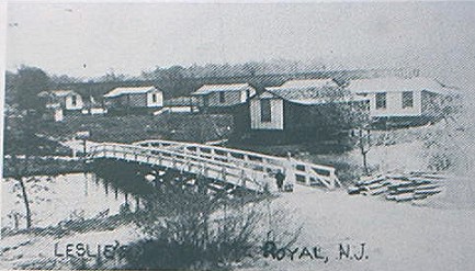 Photograph of
Leslie's Cove in Mt. Royal N.J.,
generously donated by Pete Miskofsky
Philadelphia
residents arrived at the resort by train on weekends. Its has been reported that
the cottages were built by wealthy people and were expensively furnished. Unfortunately,
the homes and the island were washed away about 1933 by floods during a severe
storm (no lives were lost). Reportedly this was a horseshoe-shaped island in the
middle of the creek. Access to the island was by a small bridge near Kings Highway.
A tall flag pole stood at the entrance just over the bridge, and each cottage
had flowers out back.

