"About
1681 The General Assembly at Burlington passed an act to survey and set forth
a public highway between Amboy and Burlington and thence to Salem, along the Indian
trail through the primeval forest." Andrew Robeson, Surveyor General of New
Stockholme, was appointed surveyor for the Fourth Tenth, to survey and construct
the King's Highway in this area.
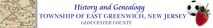
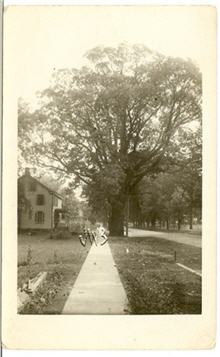
A view of Kings Highway. Photograph from the East Greenwich
Master Plan 2004
The
old Kings Highway is one of the earliest highways established in New Jersey. It
ran from Perth Amboy to Salem passing through the town of Woodbury and the villages
of Berkeley (Mt. Royal), Clarksboro and Mickleton.
The
course of the "Old Kings Highway" or "Old Salem Road" through
Mickleton has long been the subject of debate and research. It is generally agreed
that it took a southeasterly course near the Otto-Tonkin House to avoid Craft's
Hill. In 1966 Elizabeth Haines Sherman wrote scholarly thesis for her Master's
Degree that presented documented evidence that the portion of Rattling Run Road
was indeed part of the old road. In 1981 it was reported that "one of the
old highway milestones forms part of the curb today on the north side of Cedar
Road beside the Bank." In 2004 I investigated this, and could not see
a particular curbstone that looked like it was a former milestone.
In
Cushing and Sheppard's account, it is said that Salem Turnpike milestones were
placed in 1772 and 1773. In 1962 one of these milestones, in good condition, could
be found at the then Haines Funeral Home in Clarksboro, lettering "12 miles
to Coop's Ferry--21 Miles to Salem." [Coops Ferry is the current city of
Camden]. Historian's note: from what I understand from a later publication,
this milestone may have been given/donated to the Gloucester County Historical
Society. I'll be checking this to see if they have it, and if I can take a photograph
of this!
According
to the 1981 Centennial Booklet of East Greenwich, It is believed that the Mickleton
tollgate was in front of the house at 387 Kings Highway. (The book didn't say
whether this was on the same side of the street, or across the street). The toll
was about two cents. John Pedrick was the toll-taker for many years. In 1908 Daniel
Mumford bought the tollgate and moved it to the Dickerson tract in Woodbury.
Other local stories state that the Mickleton Toll Gate was a bit further
north (than the above location) on King's Highway at the corner of Toll Gate Road
and King's Highway (this would make sense considering the way that street is named).
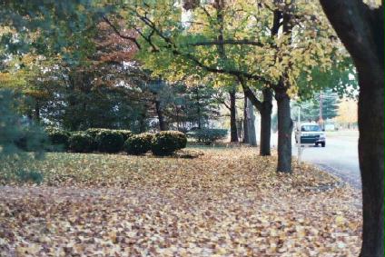
 Old Mickleton Toll Gate,
from a photograph in the 1981 Centennial booklet of East Greenwich NJ
Old Mickleton Toll Gate,
from a photograph in the 1981 Centennial booklet of East Greenwich NJ
|
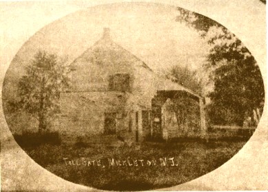
 Photograph of 367 Kings
Highway in Mickleton (taken November 2004) where it is believed that the Mickleton
tollgate was originally located (in the general vicinity, either here or across
the street).
Photograph of 367 Kings
Highway in Mickleton (taken November 2004) where it is believed that the Mickleton
tollgate was originally located (in the general vicinity, either here or across
the street). |
Sometime
in the 1940's, Ambassador Amos Peaslee of Clarksboro had a replica of a tollgate
house built next to his property (the house just south of the Peasee main house
on King's Highway, on the same side of the road). After this building was sold,
later owners changed the house's appearance, so it no longer looks like the original
"toll house."
The
road (King's Highway) was straightened to its present course in 1812. [Peaslee,
G. 69]
Variously
known as Salem Avenue, Salem Pike, Gloucester and Salem Turnpike Road, Salem Turnpike
and Swedesboro Turnpike, it once again became known as Kings Highway by ordinance
adopted April 9, 1963 by the Township Committee.
Legend
has it that Elizabeth Haddon's proposal of marriage to John Estaugh [described
by poet Henry Wadsworth Longfellow in "Tales of a Wayside Inn" occured
on the Kings Highway near Mt. Royal. (A house was built and the town of Haddonfield
was named for her). The story goes that a Quaker minister, John Estaugh came over
to America and stopped in Haddonfield. The two, in company with others of the
Quaker sect, proceeded on horseback down the King's Highway to attend the Friends
Meetings at Salem. When the party reached a point over Mantua Creek, just north
of Mt. Royal [near the four corners at Parkville Road and Kings Highway]
-- Elizabeth, pretending that her saddle girth had slipped, asked John Estaugh
to fix it. The two dismounted and dropped behind. Then Elizabeth, according to
Longfellow,
"said,
though still with a certain reluctance,
As if impelled to reveal a secret
she fain would have guarded;
I will not longer conceal what is laid upon me
to tell thee;
I have received from the Lord a charge to love thee, John Estaugh."
John
Estaugh, "surprised by the words she had spoken," did not accept at
once. He went back to England but later returned and he and Elizabeth Haddon were
married in about 1702.
Other
"famous" travelers from abroad passed over this road.
During the Revolutionary War, Lord Cornwallis and his men travelled
it, and stretched their arms around a famous oak tree which
stood at the time, just in front of the Friends Meeting House
in Mickleton.
The
Mickleton Oak, and the Howard House,
on Kings Highway in Mickelton, N.J. as mentioned
above. The house and the tree are no longer
in existence. From an old postcard
provided by Mrs. Eleanor Speich.
Crown
Prince Gustaf Adolph of Sweden rode down it in 1938 as Sweden's
representative at the Tercentary celebration of the first Swedish
landing on American Soil. The Duke of Windsor, former King of
England visited it in 1942.
That
road is still called Kings Highway and is the main thoroughfare of East Greenwich
Township. [Tercentenary; Centennial.]
HISTORY OF OTHER
PUBLIC ROADS in East Greenwich NJ Name
Changes
Road names in Mickleton have changed through the years.
.
Wolfert Station Road was previously Union Road. Today's Union Road has
also been known as Key's Mill Road or Poole's Road. .Friendship Road was
known as De Vault Road and West Wolfert Station Road was known for many years
as Bressler Road.
. Mantua Creek and Berkeley Road, sometimes referred
to as the Paulsboro Road, was once part of the Barnsboro Turnpike.This turnpike
extended from Barnsboro through Berkeley [Mount Royal] and Clonmell to Thompson's
Point and Gibbstown.
. County House Road, once known as Lawrenceville
Tunrpike
. Jefferson Road, was once part of the Old Cohocking Road,
a former Indian trail. It was also known as simply County Road.
. Cohawkin
Road was formerly known as the Cumberland Turnpike, and extended from Bridgeton
through Clarksboro to Gibbstown. [Tercentenary 14; Centennial
18 - Elizabeth T. Scott]
Laying
Out of Roads
Sand Hills to Cork's [or Cooks] Mill to Union Road 1834,
Ratting Run Road laid out in 1854, Union Road 1807, Cedar Road 1800, Jessup Mill
Road 1764, Pine Mill Road 1816, Heritage Road 1855, Berkeley to Barnsboro Road
1799.
Cohawkin
Road was laid out in 1816 as follows: "Three rods wide originally was
a native American trail bearing the Indian name, Cohocking, known in later years
as Lawrenceville (now Jefferson) and Berkley Turnpike." [Note that there
is a Cohocksink Creek in PA]. As the Lawrenceville (Jefferson) and Berkeley Turnpike
passing through the township it was laid out as a highway about 1855, at the time
when the Red Bank ferry to Philadelphia was in full operation. A toll-gate with
dwelling was located on this highway, just west of the overpass of the present
New Jersey Turnpike. This house was destroyed by fire before 1962.
In
1869 an article in the Village newspaper states: "George Sigan sold a house
and lot formerly owned by a Edward Duffield, to Jacob Hughes who intends to build
a convenience wharf on Mantua Creek, and have a dirt street opened direct to the
turnpike, for more convenient access." This street is now known as North
Street.