M A P S
1664-1815
East
and West Jersey, 1664-1702
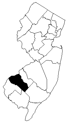
Gloucester
County Formation Map 1683-1928
John
Worlidge's Map of East & West Jersey, c. London, 1706
[largel]
A
map of Philadelphia and parts adjacent, 1752, N. Scull
New
Engelland, New York, New Yersey und Pensilvania, 1759, German
Carte
de la Nouvelle Angleterre [NY, PA, NJ] 1764, French
New
York & New Jersey commissioners line
from 41 degrees on Hudson's River taken in 1769
Province
of NJ 1777
RUTGERS UNIV. - Maps
of the American Revolution (several, circa 1777)
The
Province of New Jersey, divided into East and West, commonly
called the Jerseys; Fadden 1778
A
Plan of Fort Mifflin on Mud Island with the Attacks made by
the Kings Troops and Vessels - W. Fadden 1779
Map
of New Jersey, 1780
New
Jersey boundary lines 1784 - Map
Gloucester
County Census Map 1790-1930
1823-1913
New
Jersey 1826
Map
of New Jersey and Pennsylvania, 1839
Railroads
of New Jersey and surrounding states 1869
Railroads
of New Jersey and adjacent state 1870
GLOUCESTER
COUNTY 1872 (also Camden County)
New
Jersey Map (Ellis A. Apgar) - 1872
Railroads
of New Jersey and adjacent state 1873
Railroads
of New Jersey and adjacent state 1876
Birds
Eye View Philadelphia 1876, Toudy
GLOUCESTER
COUNTY RIVERFRONT 1877
1877
Howell Geological Survey of New Jersey
Railroads
of New Jersey 1887 (BIG FILE jpg)
New
Jersey - 1895 Map (jpg)
Pennsylvania
Railroad 1899
Drawing
of Philadelphia, Riverfront and NJ area - 1902
Pennsylvania
Railroad 1911
GLOUCESTER
COUNTY 1913 (also Cumberland & Salem Counties)
More Recent/Current
Central
Railroad 1941
GIS
and other maps of the Raritan Basin
New
Jersey County Boundaries - gif
New Jersey Geological Survey
Gloucester
County GIS map (PDF - large file, click to zoom)
Urbanized
Area (Census 2000) including Philadelphia and parts of southern
NJ (PDF, large file, clickable to zoom in)
New
Jersey Aeromagnetic and Gravity Maps
Environment
Geological
Map of New Jersey - from njfossils.net
Upper
Cretaceous & Teriary Formations of New Jersey Coastal Plain
[geological]
Gloucester
County Municipal Map (boundaries shown, from State of NJ)
- outline only, GIF
Gloucester
County Maps for Mayors (Growth of towns)
Gloucester
County WETLANDS map (from State of NJ) GIF
Gloucester
County LINEAR WETLANDS map (from State of NJ) GIF
Gloucester
County 1986 Land Use / Land Cover (from State of NJ) GIF
Statistics & More
Gloucester
County NJ - Census Quick Facts
Drought,
NJ - DEP information
Water
QualityAssessment - search for Gloucester County
Contaminated
Sites in New Jersey (by municipality)